Functional temporarily unavailable
Znamyanske
Travel guide online Znamyanske
General information about Znamyanske
Village Znamyanske is located on the territory of Autonomous Republic of Crimea and is administratively part of Evpatoriia district AR Crimea. According to the Codifier of Administrative Territorial Units and Territories of Territorial Communities of Ukraine, the settlement Znamyanske has the code UA01080550030019128.
The district center of the Evpatoriia district is a city Yevpatoriia. The distance from the district center to the settlement Znamyanske is 42 kilometers in a straight line (the length of the road route may be longer).
The former ...
Village Znamyanske is located on the territory of Autonomous Republic of Crimea and is administratively part of Evpatoriia district AR Crimea. According to the Codifier of Administrative Territorial Units and Territories of Territorial Communities of Ukraine, the settlement Znamyanske has the code UA01080550030019128.
The district center of the Evpatoriia district is a city Yevpatoriia. The distance from the district center to the settlement Znamyanske is 42 kilometers in a straight line (the length of the road route may be longer).
The former Tatar village Cheger-Adzhi received its name Znamyanske in 1945 after the forced deportation of Crimean Tatars by the Soviet occupiers from Crimea to Central Asia.
A detailed description of Znamyanske, including geographical location, date of foundation, history of the settlement Znamyanske with main historical events and persons, main sights and interesting places of Znamyanske, not yet available.
Cело Знам’янське розташоване на території Автономної Республіки Крим та адміністративно входить до складу Євпаторійського району АР Крим. Згідно з Кодифікатором адміністративно-територіальних одиниць та територій територіальних громад України, населений пункт Знам’янське має код UA01080550030019128.
Районним центром Євпаторійського району є місто Євпаторія. Відстань від райцентру до населеного пункта Знам’янське становить 42 кілометри по прямій (довжина маршруту автомобільними дорогами може бути більшою).
Назву Знам’янс ...
Cело Знам’янське розташоване на території Автономної Республіки Крим та адміністративно входить до складу Євпаторійського району АР Крим. Згідно з Кодифікатором адміністративно-територіальних одиниць та територій територіальних громад України, населений пункт Знам’янське має код UA01080550030019128.
Районним центром Євпаторійського району є місто Євпаторія. Відстань від райцентру до населеного пункта Знам’янське становить 42 кілометри по прямій (довжина маршруту автомобільними дорогами може бути більшою).
Назву Знам’янське колишнє татарське село Чєґєр-Аджи отримало в 1945 році після примусової депортації кримських татар радянськими окупантами із Криму до Середньої Азії.
Детальний опис Знам’янського, що включає географічне розташування, дату заснування, історію населеного пункта Знам’янське з основними історичними подіями та персонами, основні пам'ятки та цікаві місця Знам’янського, поки що відсутній.
Сплануй своє перебування у Znamyanske
What to see and where to go in Znamyanske
Tourist attractions and museums of Znamyanske

Belyaus Hillfort
Archaeological site
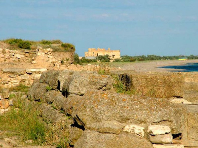
The ruins of the ancient settlement of Belyaus are located on the seashore near the western end of the Donuzlav Pass, near the village of Znamyanske.
The fortified Greek settlement of Belaus arose here in the second half of the 4th century BC. The main fortification element was a powerful multi-story tower, the impressive ruins of which have survived to this day. After several Scythian attacks, the base of the tower was strengthened with an additional anti-ram belt. The belt, made of huge blocks, was about 5 meters high and gave the building the appearance of a pyramid. Inside the tower, a well was preserved, as well as a large grain pit with the remains of wheat, millet and rye.
In addition, the foundations of economic, residential and religious complexes were discovered, in particular, a sanctuary dedicated to the cult of the dolphin, which has no analogues in the Northern Black Sea region.
In Late Antiquity, the Scythians lived here, then, until the 10th century, the Khazars.
Archaeological research is being conducted.
Reviews Znamyanske
Geographical information about Znamyanske
| {{itemKey}} | {{itemValue}} |
|---|---|
| Region |
Autonomous Republic of Crimea |


